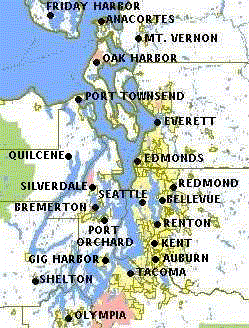
Puget Sound
Puget Sound is an estuary, a semi-enclosed body of water in which salt water from the nearby Pacific Ocean mixes with fresh water runoff from the surrounding watershed in western Washington, it is a sheltered arm of ocean between Seattle and the mainland of Washington State to the east and the Olympic Peninsula to the west. The southern boundary is marked by where the mainland and the Olympic Peninsula meet, near Olympia. The northern boundary is marked by Admiralty Pass and the Strait of San Juan de Fuca. It is the second largest estuary in the United States, Puget Sound has 3,790 km of shoreline and the Puget Sound watershed covers nearly 42,800 km² and consists of over ten thousand rivers and streams that drain into the Sound.
The Puget Sound Region consists of Puget Sound itself, the islands of Puget Sound, the Kitsap Peninsula, plus the mainland counties which form both the western and eastern sides of Puget Sound leading up to the edges of the watershed in the high crests of the Cascade and Olympic mountain ranges. Counties with this area include: Island, Snohomish, Kitsap, King, Pierce, and Thurston
Regions
It is difficult to break down Puget Sound into smaller regions because there are so many different geographic, cultural and political ideas that it entails. Locals generally refer to Puget Sound as both the body of water and the geographic area surrounding it, but even different bodies of government define Puget Sound as having different physical boundaries. For the sake of clarity Wikivoyage uses the National Oceanic and Atmospheric Administration (NOAA)official breakdown into five main regions.
- North Puget Sound region lies north of the Admiralty Inlet and Port Townsend and west of Whidbey Island. Includes the city of Bellingham and the picturesque San Juan Islands.
- King County, where Seattle is located, also has some unique suburbs, such as Bellevue, Redmond, Woodinville, Kent and many others that extend north, east and south from the core. Bordered to the west by the Kitsap Peninsula this region also includes Vashon Island and Blake Island.
- Kitsap Peninsula
- Whidbey Basin separates Whidbey Island from Camano Island the mainland and includes the city of Everett, at the north end is the famous and turbulent Deception Pass.
- South Puget Sound region includes the cities south of Tacoma and the state capital at Olympia, further south.
- Hood Canal stands as its own separate hook shaped branch of Puget Sound and separates the Kitsap Peninsula from the Olympic Peninsula
Cities
- lies across Lake Washington to the east of Seattle. It is the fifth largest city in the state.
- is the main city within the Kitsap Peninsula. This harbor town is fun place to explore.
- is the main city on the North Sound.
- small historical harbor town near the Tacoma Narrows Bridge.
- lies at the southernmost bit of Puget Sound. It is the beautiful state capital.
- classic harbor town with downtown shopping area on the Kitsap Peninsula.
- historic port with its turn of the century buildings is popular with tourists.
- , home of Microsoft, is on the Eastside of Seattle and offers parks, shopping, and more.
- is by far the largest city in the region. It is the heart of a vibrant metropolitan area and a major tourist destination.
- is a popular town on the Kitsap Peninsula with amazing views of Puget Sound.
- is another major city in the South Sound. Formerly mostly industrial, the city center has been beautified, and the city now offers attractions such as the famous Museum of Glass, Point Defiance Park, and the Washington State History Museum.
Other destinations
Understand

History
Puget Sounds complex series of waterways were formed from receding glaciers that left the area about 14,000 years ago cutting deep into the land forming valleys that eventually flooded creating the intricate landscape that we know today.According to scientific data the first people arrived in Puget Sound about 12,000 years ago, but according to native Suquamish people, legend says that all of the earth was water, then the Old One dried the land and created everything from mud, he used the last mud balls from the earth to create the people. Then he sent Coyote to teach the people how to live with the earth, Coyote traveled the earth teaching the people and making life better for them.
By 1792 when Captain George Vancouver named the area after one of his officers and declared the area for Great Briton, the Suquamish and Salish people had already developed a multi facetted and complex society of their own. The Suquamish people called Puget Sound the Lushootseed name 'WulcH, which simply means "Salt Water". For thousands of years the Suquamish traveled the waters of Puget Sound in well designed cedar canoes and before settlers developed roadways a complex series of ferries known as the ‘Mosquito Fleet’ was also the main way people and goods were transported around the area and waters of Puget Sound became the first regional highway.
Once the Washington Territory was established in 1853, the U.S. government began signing treaties with area tribes to acquire their lands. The Suquamish people ceded most of their land to the United States and logging came into the area in full force. The areas once impassible thick forests gave way to farms, towns and industry as lumber was shipped off to areas such as San Francisco or burned as fuel for the growing fleet of boats.
Today the area has grown in international influence with economic powerhouses such as Boeing, Starbucks and Microsoft whose global reach is far beyond Washington State borders. Seattle is the largest cosmopolitan city with millions of people and the regions cultural influence is profound with many artistic and cultural endeavors reaching an international audience. Yet through all of this growth and change the people of the region are still tied to Puget Sound not only for transportation and source of food but as the symbolic center of area culture.
Boundaries
Despite common belief and contrary to widespread usage there is some debate on the exact boundaries of the area we call Puget Sound. For the sake of clarity we are using the boundaries established by National Oceanic and Atmospheric Administration (NOAA) which draws the northern border along the Canadian border and Straight of Georgia. There has been a recent popular movement to officially name the area that contains the Strait of Juan De Fuca, all of Puget Sound and the Strait of Georgia as the Salish Sea, in honor of the native people of the region (referred to as 'First Nations' people by Canadians).Talk
There are ethnically diverse neighborhoods in the Seattle area where many languages are spoken, including a large International District where many Asian languages are spoken. Washington is the thirteenth most populated state for example, but by comparison has the fourth highest Asian population. Seattle's 98118 zip code centered around the Columbia City neighborhood in South Seattle is considered the most ethnically diverse zip code in the country by the US Census bureau with 59 different languages regularly being spoken.
Chinook Jargon was a pidgin or trade language established among indigenous inhabitants of the region. After contact with Europeans, French, English, and Cree words entered the language, and "eventually Chinook became the lingua franca for as many as 250,000 people along the Pacific Slope from Alaska to Oregon." Chinook Jargon reached its height of usage in the 19th century though remained common in resource and wilderness areas, particularly but not exclusively by Native Americans and Canadian First Nations people, well into the 20th century. Chinook Jargon was still in use in Seattle until roughly the eve of World War II, making Seattle the last city where the language was widely used. Today its influence is felt mostly in place names and a handful of localized slang terms. Pronunciation of some of these terms is difficult and often separates the visitor from the local including Alki, Seattle, Kitsap, Yakima, Duwamish and Lummi.
Get in
By plane
- Seattle-Tacoma International Airport (SEA), universally nicknamed "Sea-Tac", is in the city's southern suburbs. Domestically it's a major hub for Northwest and West Coast destinations, and internationally handles especially frequent trans-Pacific routes, as well as direct flights to the major European airports. The airport is about a 25-minute drive from downtown Seattle when there isn't heavy traffic, much longer during rush hour. All information about the airport, including any means of ground transportation, is covered in a separate article.
- Bellingham International Airport (BLI) has scheduled flights to Seattle, Las Vegas, andHonolulu, through Horizon Air and Alaska Airlines. Allegiant Air has service to Las Vegas, Los Angeles, Oakland, Palm Springs (seasonal), Phoenix, and San Diego. Frontier Airlines has service to Denver. San Juan Airlines has commuter flights to the island towns of Eastsound, Friday Harbor, Lopez, and Roche Harbor, plus Vancouver, Canada.
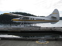
- Sea Planes are another popular way to travel around Puget Sound with several airlines based out of Seattle including Kenmore Air serving areas all around Puget Sound and Canada.
By train
Amtrak has three train services that serve the Puget Sound area. Cities served are Seattle, Tukwila, Tacoma, Olympia, Edmonds, and Everett: see the "Get in" sections of those cities for more details.- The Coast Starlight train starts in Seattle and heads south through Tukwilla, Tacoma, Olympia, Portland, and ultimately San Francisco and Los Angeles in California.
- The Empire Builder starts in Seattle, goes to Everett then heads east across the mountains to Spokane and eventually Minneapolis and Chicago.
- Amtrak Cascades is a regional train service that goes north from Seattle to Vancouver and south to Portland and Eugene.
By car
I-5 is the main freeway running north-south; going north to Vancouver and south to Portland and California. I-90 goes east from Seattle to Spokane, Chicago and ultimately Boston. Other east-west routes include US-2 over Stevens Pass from Everett and SR-410 from Tacoma (closed in winter).By bus
-
phone: +1 360 380-8880address: (company office & bus garage) 1416 Whitehorn St, Ferndale, WA 9824811 round-trips daily to Sea-Tac from Blaine, Birch Bay, Lynden, Ferndale, Bellingham, Burlington, Stanwood and Marysville along the I-5 corridor. They offer a second route from Burlington to the Anacortes/San Juan Ferry Terminal via La Conner and Anacortes. Passengers coming typically transfer in Burlington from the I-5 Corridor route to continue westward to the Anacortes/San Juan Ferry Terminal.
BoltBusDirect service into the region from Portland to the south and from Vancouver, BC in north.
GreyhoundRuns along the I-5 corridor between Seattle and Vancouver, BC (via Everett, Mt Vernon & Bellingham) on one route and to Portland (via Tacoma, Olympia, Centralia & Kelso) on the other. They also run along I-90 across eastern Washington between Seattle, Spokane and Missoula, MT.
Quick ShuttleRuns between Seattle and Vancouver, BC. Stops in Downtown Seattle (outside the Best Western at 200 Taylor Ave N) and SeaTac Airport (at the main terminal near south end of baggage claim, outside door 00, bays 11-16). Fares from Vancouver to Downtown Seattle are $36 one-way, $65 round-trip; from Vancouver to SeaTac, fares are $49 one-way, $87 round-trip.
By ferry
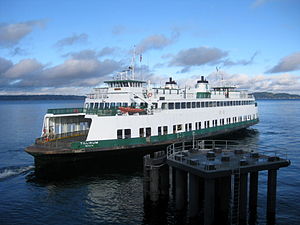
- Washington State Ferries +1 206 464-6400 . Connects downtown Seattle to Bainbridge Island, Bremerton, and Vashon Island, and connects West Seattle to Vashon Island and Southworth (Kitsap Peninsula). All ferries are for both vehicles and passenger except the ferry between downtown Seattle and Vashon Island which is foot traffic only.
- Victoria Clipper. High speed catamaran passenger ferries which connect Seattle to Victoria, British Columbia and the San Juan Islands.
- The Alaska Marine Highway System (also see ) operates a ferry service from Bellingham, Washington up the Inside Passage to Haines Alaska. Plan your travel early as this service tends to fill up fast.
By cruise ship
Cruise ships to Seattle may be docked at one of two terminals in the Port of Seattle.- Bell Street Pier Cruise Terminal at Pier 66, 2225 Alaskan Way S, near the middle of Seattle downtown's waterfront, serves as home port for Norwegian Cruise Line and Celebrity Cruises. Has bus, taxi and shuttle connections for transfer of passengers and luggage. For travelers with connecting flights, Seattle-Tacoma International Airport is less than 15 mi (24 km) away.
- Smith Cove Cruise Terminal at Pier 91, 2001 W Garfield St, at the north end of Seattle's downtown waterfront, serves as home port to Holland America Line, Royal Caribbean and Princess Cruises.
By boat
It is not coincidence that so many cities in this region are located on the water. Early settlers found the thick regional forests too impenetrable to navigate by land so waterways became the Pacific Northwests early highway system.However when arriving from Canada there are only a handful of ports including Roche Harbor, Friday Harbor, Anacortes and Bellingham that are official U.S. ports-of-entry and can process boaters through customs. The Cardinal Rule is touch land at customs dock before any other stops, fines for not doing so can be up to $5000. Besides a passport for everyone on board, you will need your boat's license number and User Fee Decal number.
Customs enforces USDA guidelines for what foods are acceptable to bring into the country and these guidelines are constantly changing so it is best to check in with them before arriving. Boaters are responsible for knowing the prohibited foods and can be fined for not declaring them.
The Puget Sound region offers a wide variety of guest marinas throughout the area. Check city listings for specific marina information.
- The Washington State Parks and Recreation Commission has the largest state-managed mooring system in the United States. The commission manages more than 40 marine parks in Puget Sound that together provide more than 8,500 feet of public moorage space.
Get around
By ferry
Washington State Ferry routes cross Puget Sound including several islands including Bainbridge, Vashon, Whidbey and the San Juan Islands. There are also some county-run ferries to smaller destinations such as to Anderson Island and Guemes Island.
By car
Outside the main cities public transportation is scarce and is not of much use for extensive sightseeing, so renting or arriving by car is advisable. Although distances can be long, most roads are paved and well-maintained. Be aware of distances between gas stations and plan accordingly when traveling in rural areas. Most ferries accept vehicles and utilizing them is key to navigating the area.By bus
Regional transit systems tend to be organized by county however they are often interconnected to cover larger areas and some are coordinated with Washington State Ferries, with each other (for one to arrive within minutes of the next one leaving) and have many coordinated pickups at Seatac airport. Not the fastest way to travel but efficient and cheap for the budget traveler and are the only way available in the (more rural) areas west of the Puget Sound. See the below:Along West Side of Puget Sound With the exception of the Dungeness Line, the county operated transit systems are the only way around the Olympic Peninsula without a car on the west side of the sound. Schedules are less frequent on rural routes then local services within the cities/towns.
-
Dungeness Line operated by Olympic Bus Lines
phone: +1 360 417-0700The Dungeness Line, operated by Olympic Bus Lines provides two trips daily between Port Angeles, Sequim, Port Townsend, Discovery Bay, and Kingston, to and from Edmonds, downtown Seattle, and Seattle Tacoma International Airport. It is a privately operated bus between Seattle and the Olympic Peninsula Clallam TransitBuses in Port Angeles (Rt #20-24), Joyce (#10), Forks (Rt#14 - 17), Neah Bay (Rt#16), La Push (#15) and Sequim (Rt#30-52) in Clallam County. Connects to Jefferson Transit in Sequim and Forks. The "Strait Shot" bus (Rt #123) runs 3x daily (M-F) and twice on Saturdays from Port Angeles to Poulsbo where passengers transfer to a Kitsap Transit bus to continue to the ferry terminal to Seattle from Bainbridge Island or the ferry to Edmonds from Kingston.
-
phone: +1 360 385-4777Local buses in Port Townsend and to Sequim, Quilcene, Port Ludlow, Brinnon & Poulsbo, as well as the "West End" from Forks to Amanda Park along US Hwy 101 through Jefferson County.
Kitsap TransitBuses in Bremerton, Bainbridge Island, Poulsbo, Kingston, Suquamish, Silverdale,and Port Orchard in Kitsap County. Limited service to Purdy just over the Kitsap/Pierce County line.
-
phone: +1 360 532-2770address: 790 E Johns Prairie Rd, Shelton, WA 98584Local buses in Shelton and to Belfaire, Bremerton and Brinon Connects to Intercity Transit and Grays Harbor Transit in Olympia; to Kitsap Transit in Bermerton and to Jefferson Transit in Brinnon.
Along East Side of Puget Sound The eastside is more populated and therefore, offer more frequent schedules on more routes. If you're trying to get from Olympia to Port Townsend, Bremerton or Widbey Island it would be quicker to get a series of buses up into Seattle and taking the ferry across than the buses along the west side of the Sound.
-
phone: +1 360 380-8880address: (company office & bus garage) 1416 Whitehorn St, Ferndale, WA 9824811 round-trips daily to Sea-Tac from Blaine, Birch Bay, Lynden, Ferndale, Bellingham, Burlington, Stanwood and Marysville along the I-5 corridor. They offer a second route from Burlington to the Anacortes/San Juan Ferry Terminal via La Conner and Anacortes. Passengers coming from Seattle and Sea-Tac transfer in Burlington from the I-5 Corridor route to continue westward to the Anacortes/San Juan Ferry Terminal.
BoltBusIn the area they only stop into Bellingham and Seattle.
GreyhoundRuns along the I-5 corridor between Vancouver BC, Bellingham, Mt Vernon, Everett, Seattle, Tacoma and Olympia. Quicker to get across longer distances such as from Olympia up to Bellingham than a series of county operated buses.
-
phone: +1 206 553-3000The long distance public transit operator operates express bus services from and between cities in the four county Seattle metropolitan area such as Tacoma (Rt #586,590,592,594,595,574), Bellevue (Rt 532,550,554,556,560,565), Everett (Rt #510,512,513,532), Bothell (Rt #522), and other cities/municipalities surrounding Seattle.
-
phone: +1 425 353-RIDETransit services around Everett and Snohomish County (Arlington, Brier, Bothell, Edmonds, Lynnwood, Lake Stevens, Marysville, Monroe, Snohomish, Stanwood, etc.) and express services from various points in Snohomish County to downtown Seattle and the University of Washington in the mornings and up to Snohomish County in the afternoons. Local bus service within the city of Everett is provided by Everett Transit.
Intercity TransitOperates local buses in/around Olympia, Lacey and Tumwater in Thurston County and express buses up to Tacoma and Lakewood along I-5 (Rt #612,620).
-
phone: +1 360 678-7771 or +1 360 387-7433Operates local services up and down Whidbey Island and on around Camano Island as well as the Coupeville and Clinton Ferry Terminals; local services within Oak Harbor and intercounty services to Mt Vernon in Skagit County from Whidbey Island and Camano Island and Everett from Camano Island.
King County MetroOperates buses within Seattle and out to outlying suburbs & cities within King County such as Federal Way, Shoreline, North Bend, Renton, Kent, Bothell, Bellevue, Kirkland, Shoreline, Issaquah, North Bend, and Enumclaw. The rule of thumb is that the three digit line numbers are for service to/from outside the Seattle city limits. There are other routes that operate locally within the suburbs and between the suburban cities that do not come into Seattle at all.
-
phone: +1 253 581-8000Local buses in Tacoma, Federal Way, Lakewood, Puyallup, Steilacoom and University Place. Limited service to Buckley, Gig Harbor, Bonney Lake/Lake Tapps.
-
phone: +1 360 757-4433address: Intermodal Station @ 105 E Kinkaid in Mt VernonLocal buses in Mt Vernon, Burlington, Anacortes and other points in/around Skagit County. County Connector Service to Everett on Rt #90x and Bellingham on Rt #80x.
-
phone: +1 360 676-7433Operates buses between Bellingham, Ferndale (Rt #27), Lynden (#26), Blaine (#75), Lummi Reservation (#50) and other places in/around Whatcom County. They also go to Mt Vernon on Rt #80x in neighboring Skagit County. They don't cross the international border or go into Point Roberts.
By light rail
Light rail is growing rapidly in the area, but only one line is operating, from Angle Lake Station to University of Washington Station, with stops at SeaTac Airport, South Seattle, Downtown Seattle, and Capitol Hill along the way.See
Blake Island State ParkA popular island state park accessible only by boat that was the birthplace of Chief Seattle and still offers guests Native American style dinners and dancing.
- Deception Pass Bridge, a National Historic Monument since 1982, is actually two spans that link Whidbey Island near Oak Harbor to Fidalgo Island over Canoe Pass and Deception Pass. The bridge, one of the scenic wonders and destinations of the Pacific Northwest, was a Public Works Administration project built by the Civilian Conservation Corps. Deception Pass State Park, has over 4,100 acres (17 km²) of forest, campsites, trails, and scenic vistas of the San Juan Islands, Victoria (British Columbia, Canada), Mount Baker, and Fidalgo Island.
- Ebey's Landing National Historical Reserve preserves and protects an unbroken historical record of Puget Sound exploration and settlement from the 19th century to the present. Historic farms, still under cultivation in the prairies of Whidbey Island, reveal land use patterns unchanged since settlers claimed the land in the 1850s.
Hood CanalDespite its name, it is not a canal but an inland fjord that stretches for over 70 miles separating the Kitsap Peninsula from the Olympic Peninsula. It is a prime destination in the area for outdoor recreation and nature viewing with sweeping views of the Olympic Mountains and lush forests. Near the southern end of the Kitsap Peninsula it hooks inward at an area known as the Great Bend.
Kitsap Peninsula
The Kitsap Peninsula is almost an island attached by a relatively small landmass near Belfair, its complex coastline dominates the Puget Sound area between Hood Canal and the Main Puget Sound Channel. It is home of several cities and towns and is accessible by the Tacoma Narrows Bridge near Tacoma and the floating Hood Canal Bridge giving access on the northern end to the Olympic Peninsula and to several ferry terminals giving access from Seattle and Edmunds.Islands
- Anderson Island - southernmost island in Puget Sound.
- Bainbridge Island - residential island connected by bridge to Kitsap Peninsula and ferry from Seattle.
- Blake Island - state park between Seattle and the Kitsap Peninsula.
- Fidalgo Island - 2nd most populous island and ferry terminal to the San Juans.
- Fox Island - forested island near Gig Harbor.
- Hartstine island - serene forested island with a state park.
- Lummi Island - quiet island served by a small ferry.
- Vashon Island - served by ferries from Tacoma and Seattle.
- Whidbey Island - longest island in Puget Sound.
Other areas
- Ebey's Landing National Historical Reserve - Historical features of the reserve appear to today's visitors much as they did a century ago, when New England sea captains were drawn to Penn Cove
- Klondike Gold Rush - Seattle Unit National Historical Park - offers a glimpse at the stories of adventure and hardship of the gold rush
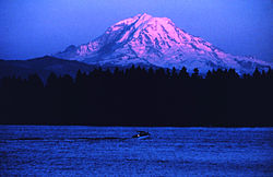
- Mount Rainier National Park - an active Cascade volcano encased in over 35 square miles of snow and glacial ice
- Big Four Ice Caves — caves carved in the year-round glaciers on the shadowed side of Big Four Mountains by streams of snowmelt
- Crystal Mountain
Do
Beachcombing
Sea shells and driftwood are considered part of the natural environment and should not be removed, however the often rocky and wild shores are havens for creating and revealing beach glass and anything artificial found is fair game for removal. Be respectful of private property and gentle with sea creatures. Keep a wide distance away from nesting birds, seals and other shore animals and always put back anything removed from the shoreline.
Boating
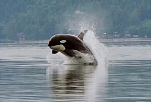
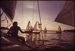
Puget Sound offers some of the best recreational boating in the world. Breath taking views of the snow capped Olympic and Cascade mountain ranges along with glimpses of Mount Rainier mingle with thick forests and clear bays and streams to create a humbling cacophony of natural sights. Carved by ancient glaciers, Puget Sounds intricate and complex waterways provide endless opportunities for exploration while the many harbor towns built on protective bays cater to boaters and provide an wide array of services, restaurants and shops. Harbor Seals, Otters, Sea Lions, Bald Eagles and Blue Herons are common sights while the occasional viewing of an Orca or Grey Whale is not out of the question.Sailing
The Puget Sound is a destination celebrated by sailors from around the world. The scenery around Puget Sound can be so amazing that it borders on the surreal and could only possibly be appreciated more from the deck of a boat under sail. From isolated moorages in such places as Blake Island State Park to historic harbor towns with fine restaurants, museums and shopping all accessible from convenient harbors.
Sea kayaking
Sea kayaking can be a rewarding way to explore the Puget Sounds miles of coastline allowing the paddler a closer and slower look at their surroundings and making Puget Sound a popular area to sea kayak. Both urban and rural areas offer their own rewards and many organized tours are available in different areas.Kayak trails
Organized trails offer overnight camping options and maps of appropriate travel lengths and scenic travel destinations. For thousands of years native Salish tribes navigated these waters in small, well designed wooden boats and many of these trails were developed along their same paths.Cascadia Marine TrailThis inland sea trail is a National Recreation Trail and designated one of only 16 National Millennium Trails by the White House. Suitable for day or multi-day trips, the Cascadia Marine Trail has over 50 campsites to visit. People can boat to the campsites from many public and private launch sites or shoreline trailheads.
Kitsap Peninsula National Water TrailsThe National Parks Service named the this 'Trail of the Month' in December 2012. PDF copies of the water trails map are available
Key Peninsula Marine TrailA 40-mile (64-km) marine trail with 14 legs between 15 points of interest during a paddling journey around the Key Peninsula
Bird watching
- Go bird-watching and see some of the 300+ species of birds found in Puget Sound.
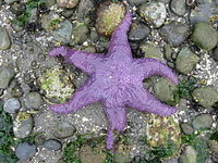
Scuba diving
Diving the cold waters of Puget Sound takes a bit more gear and training than other warm water locations, but the rewards are incredible. The area contains some of the best diving in the world and many areas are accessible from the Kitsap Peninsula. Many dive sites are completely covered with colorful sea creatures that defy description. Giant Pacific Octopus are common, along with friendly wolf eels. Colorful sponges, sea cucumbers, sea stars, soft corals, anemones and fish can be seen on nearly every dive. The state has offers a guide to parks with launch sites here-
Sound Dive Center
phone: +1 360-373-6141address: 5000 Burwell Street, Bremerton, WA 98312Established in 1972, this diving center offers a full range of diving gear and classes.
Eat
The Pacific Northwest is a foodie’s dream come true. Talented chefs and entrepreneurs have taken advantage the northwest’s incredible seafood, abundant locally sourced produce, award-winning wines, and a well developed beer brewing tradition to establish a regional cuisine that trumps just about any other area in America. The Puget Sound region offers top of the line restaurants squirreled away in almost every neighborhood Pacific north westerners have high expectations from their food.
The Pacific North West is perhaps best known for its salmon, but a large variety of other seafood is available in the area. Oftentimes seafood comes in short bursts with seasonal migrations such as the areas fall Salmon runs available for only short amounts of time so watch closely for seasonal specials in restaurants and markets.
Shellfish are the prized resources of the Puget Sound, the cool, clean waters provide some of the finest shellfish habitat in the world. Washington State is the nation’s leading producer of farmed bivalve shellfish (clams, mussels and oysters) but other specialties like Geoducks are sometimes available for the more adventurous.
The Dungeness Crab is a popular seafood prized for its sweet and tender flesh and high ratio of meat. Its common name comes from the port of Dungeness, Washington where the first commercial harvesting of the crab was done. The Dungeness Crab is a commercially important crab in the state of Washington's territorial waters and was the first shellfish harvested commercially in the area but other crab species are also common.
The areas mild climate, rich soil and abundant water resources have created a bountiful climate for the many varieties of fresh produce available across the region. Farmers markets are common in both urban and rural areas and a great way to experience local culture as well as experience local foods.
Drink
Microbreweries and beer in general are a Northwest specialty, and the area has many to offer for beer enthusiasts. The larger brewers, like Redhook and Pyramid, distribute their products regionally or nationally like their coffee cousins, while other brews can only be found in local stores or bars (some notable brewers don't even bottle their product). Ask your servers for local beer recommendations and search out regional microbrews in stores. Hops are the key ingredient in beer making and Washington State's neaby Yakima Valley is by far the biggest exporter of hops in the US giving area brewers another edge in making the best beers.
Vineyard in Willamette Valley
There are many great wineries spread across the Puget Sound region such as The Chateau Ste. Michelle in Woodinville, which is not only the oldest winery in the state but is the largest single producer of Riesling wine in the United States.