Plains (India)
Sourced from Wikivoyage. Text is available under the CC-by-SA 3.0 license.
States
Cities
Here are nine of the most notable cities.
- — the capital of India
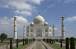
- — home of the Taj Mahal
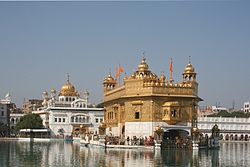
- — contains the Golden Temple, the most important centre of pilgrimage for Sikhs
- — the capital of Madhya Pradesh
- — the capital city of both the Punjab and Haryana, which was designed by Le Corbusier
- — originally a hilltop fortress, now famous for its fort and St. Jude's Shrine
- — the Golden City of the East
- — the gateway to the Buddhist and Jain pilgrim centres
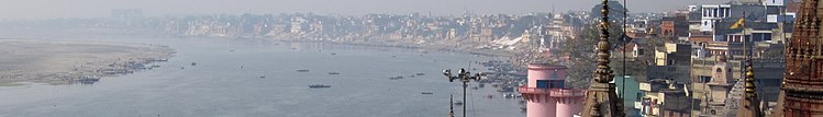
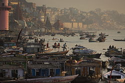
- — a sacred Hindu city on the banks of the Ganges
- — a sacred Hindu city on the banks of the Ganges
- — the gateway to the Buddhist and Jain pilgrim centres
- — the Golden City of the East
- — originally a hilltop fortress, now famous for its fort and St. Jude's Shrine
- — the capital city of both the Punjab and Haryana, which was designed by Le Corbusier
- — the capital of Madhya Pradesh
- — contains the Golden Temple, the most important centre of pilgrimage for Sikhs
- — home of the Taj Mahal
Other destinations
- , Uttar Pradesh — an expanse of approximately 811 sq km of marshes, grasslands and dense forests representing a very rich ecosystem. It is also part of the Dudhwas Tiger Reserve
- , Punjab — this has a diversity of wetland animals and plants. It was Harike Pattan Bird Sanctuary and is known for its many species of migratory birds. It is habitat for several endangered species such as the Testudines Turtle and Smooth Indian Otter
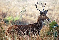
- , Madhya Pradesh — located in the rugged terrain of the Satpura hills, this park habitat for a large diversity of animals such as the tiger, leopard, wild dog, chital, wild boar and wide variety of birds. On rare occasions, elephants, lions and water buffalo have visited the park.
- (Sultanpur Bird Sanctuary), Haryana — this park provides habitat and feeding grounds for many migratory birds such as the Siberian crane as well as the many resident bird species found here
- (Valmiki National Park and Wildlife Sanctuary), Bihar — this pristine forest, grassland and wilderness is part of the Valmiki Tiger Reserve
- (Valmiki National Park and Wildlife Sanctuary), Bihar — this pristine forest, grassland and wilderness is part of the Valmiki Tiger Reserve
- (Sultanpur Bird Sanctuary), Haryana — this park provides habitat and feeding grounds for many migratory birds such as the Siberian crane as well as the many resident bird species found here
- , Madhya Pradesh — located in the rugged terrain of the Satpura hills, this park habitat for a large diversity of animals such as the tiger, leopard, wild dog, chital, wild boar and wide variety of birds. On rare occasions, elephants, lions and water buffalo have visited the park.
- , Punjab — this has a diversity of wetland animals and plants. It was Harike Pattan Bird Sanctuary and is known for its many species of migratory birds. It is habitat for several endangered species such as the Testudines Turtle and Smooth Indian Otter
Understand
Talk
Given that the Plains are the Hindi Belt, Hindi and Urdu are widely spoken in almost all of the states, with the exception of Punjab, where Punjabi dominates. As in the rest of India, English is a very commonly learned second and third language.
Get in
By plane
All major cities in the area have airports. Delhi's Indira Gandhi International Airport is large, and likely to be the point of entry for most foreign visitors to this region. Domestic flights from other parts of India are also commonplace.By train and bus
Long-distance trains travel from all other parts of India to this region. The same is true of long-distance bus lines.Get around
There are numerous train connections between the major cities in this region. Domestic flights for longer distances are also possible. Buses also traverse this area.
See
Do
- For a unique experience and view, take a boat trip on the Ganges.
Eat
Drink
Northern India is the land of milk-based drinks such as lassi. Masala chai — tea with milk and a blend of spices — is also a common beverage in this region.